File:Systemic numbering in the Public Land Survey System.gif
Jump to navigation
Jump to search

No higher resolution available.
Systemic_numbering_in_the_Public_Land_Survey_System.gif (412 × 287 pixels, file size: 15 KB, MIME type: image/gif)
Summary[edit | edit source]
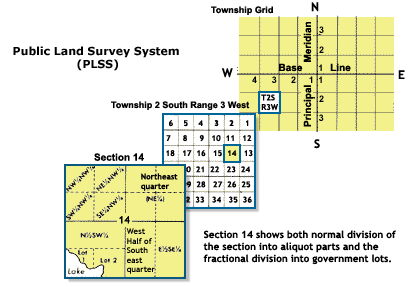
diagrams of Rectangular land survey system
Licensing[edit | edit source]
|
|
This work is in the public domain in the United States because it is a Work of the United States Government under the terms of Title 17, Chapter 1, Section 105 of the US Code. See Copyright. Note: This only applies to works of the Federal Government and not to the work of any individual U.S. state, territory, commonwealth, county, municipality, or any other subdivision. This template also does not apply to postage stamp designs published by the United States Postal Service since 1978. (See 206.02(b) of Compendium II: Copyright Office Practices). |
 |
File history
Click on a date/time to view the file as it appeared at that time.
| Date/Time | Thumbnail | Dimensions | User | Comment | |
|---|---|---|---|---|---|
| current | ★ Approved revision 21:16, 27 September 2015 | | 412 × 287 (15 KB) | Hanna5974 (talk | contribs) | diagrams of Rectangular land survey system |
You cannot overwrite this file.
File usage
The following page uses this file: