File:HawaiiMap.gif
Jump to navigation
Jump to search

No higher resolution available.
HawaiiMap.gif (404 × 235 pixels, file size: 41 KB, MIME type: image/gif)
| Description |
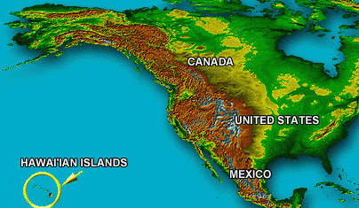
Map showing the location of the Hawaiian Islands in relation to North America. | |||
|---|---|---|---|---|
| Author |
USGS (United States Geological Survey). | |||
| Source |
Emily Bischof's Cartography Webpage, UCLA Geography 167, Summer 2008, (accessed 14 September 2008), displaying a USGS logo, and this non-functioning URL http://TerraWeb.wr.usgs.gov/projets/CoralReefs. | |||
| Date |
2008? | |||
| Permission |
|

|
|
This is a retouched picture, which means that it has been digitally altered from its original version. Some of the modifications are: cropped to show only the lower left inset of location of islands compared to North America. Cropped out larger Molokai and Hawaiian chain. |
File history
Click on a date/time to view the file as it appeared at that time.
| Date/Time | Thumbnail | Dimensions | User | Comment | |
|---|---|---|---|---|---|
| current | ★ Approved revision 23:14, 14 September 2008 | | 404 × 235 (41 KB) | Dsammy (talk | contribs) | US Government |
You cannot overwrite this file.
File usage
The following page uses this file: